


Oregon’s New Defensible-Space Standards Don’t Apply to Every Property, But They Should
Homes on Moderate and even Low risk properties are still vulnerable to wildfire.

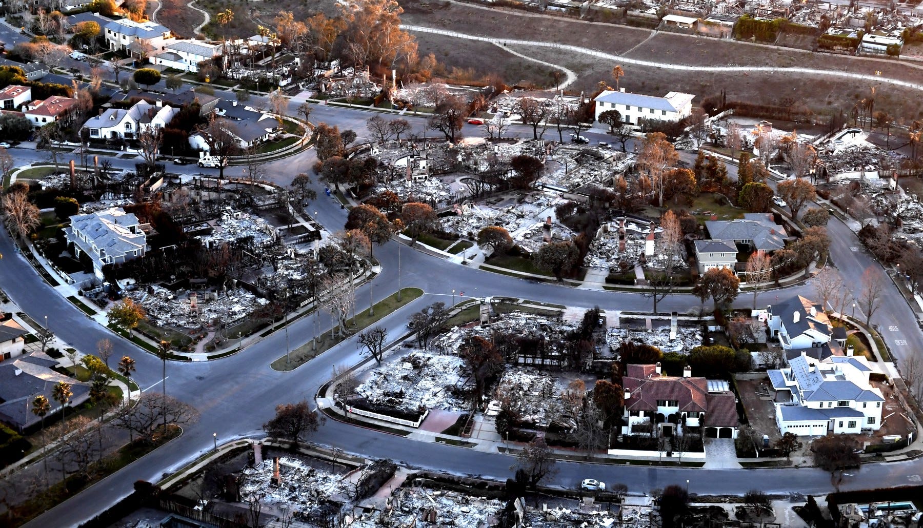
Homes burned and unburned in the Palisades Fire near Pacific Palisades, California, January 14, 2025. Public domain image.
By Steve Wilent
The State of Oregon’s Wildfire Risk Explorer map was finalized in January, along with new defensible-space standards. A home-hardening building code (regulations designed to make homes more resilient to wildfire) is in draft form.
The map and regulations have drawn howls of protest from folks who disagree with the hazard class assigned to their property, are worried about the costs of complying and the penalties for not doing so, and/or see this as unwelcome governmental overreach. See, for example, “State’s fire map catches heat in Deschutes County,” in the Bend Bulletin, February 14, 2025. State lawmakers are considering eliminating the map entirely, reported the Salem Statesman Journal and others in mid-February. One Oregon lawmaker has proposed revising the map so risk levels apply broad areas rather than indicating the risk on individual properties.
I’m sympathetic to the opposition to the map, etc., but scrapping it would be a mistake.
After the 2020 Labor Day fires in Oregon, in which about one million acres burned and 2,800 homes were destroyed, the state legislature passed bills to mandate the creation of the map, standards, and code, in an effort to help Oregon residents and businesses improve their wildfire preparedness. All tax lots in the state are assigned one of three wildfire hazard classes: Low, Moderate, or High; US Forest Service, Bureau of Land Management, and other public lands also are rated.
The owners of tax lots that are both rated as at a high hazard and in a wildland-urban interface zone are required to meet the defensible-space standards and, for new construction only, the home-hardening code. That comes to about 6 percent of all tax lots in the state—roughly 106,000 properties.
Despite the sharp criticism, this effort is a much-needed and well-intentioned project. The people who built the map, wrote the standards and code, and explained it all to an often dubious or even angry public deserve our praise and gratitude.
However, there’s a big problem: The owners of the other 94 percent of tax lots—roughly 1,786,000—rated at Low or Moderate hazard will not be required to take any action to create defensible-space around their homes or businesses.
Those property owners—I’m one of them—may be breathing sighs of relief that they aren’t required to create a defensible space or follow the home-hardening code. In my view, such complacency is dangerous. Houses and entire neighborhoods are still at a significant risk of being destroyed by a wildfire.
Consider the devastating fires in the Los Angeles area in January. Collectively, the seven fires in one of the most highly developed metropolitan areas in the world, whipped by strong, warm, east winds, destroyed more than 18,000 homes and other structures and killed at least 29 people. In February, heavy rains fell on the area, causing mudslides in the burned areas and elsewhere.
The Palisades Fire, on the Pacific coast north of L.A., burned more than 23,700 acres and 6,837 homes. On the California’s Fire Hazard Severity map, the burned area is not shown as having any fire hazard rating. Portions of the Eaton Fire (14,021 acres and more than 9,000 buildings near Altadena, California) burned in or near areas designated as Very High fire danger zones. Despite their proximity to steep, brushy hillsides, the suburban neighborhoods that burned were not identified as having any level of wildfire hazard.
In parts of these wildfires, houses, not forests or hillsides choked with brush, were the primary fuel for the flames. The fires burned from house to house, sometimes leaving green trees standing amid the destruction.
Fires like these could very well burn in Oregon—and have. As the survivors of the 2020 Almeda Fire can attest, more than 2,800 structures were destroyed in communities north of Ashland, in southwestern Oregon.
On the Oregon Wildfire Risk Explorer map, Grants Pass, a city of 40,000, is an island of Low hazard surrounded by a reef of Moderate hazard in a sea of High hazard areas. The same goes for Medford, Ashland, and Bend. Folks in Eugene might feel safe in their Low-hazard city, though it, too, is surrounded by Moderate areas, with a swath of High not far to the east. Newport, on the coast, is rated as Low, but the Coast Range between it and Corvallis is solid Moderate. Some of Oregon’s largest wildfires have burned in the verdant Coast Range, such as the series of fires known as the Tillamook Burn, beginning in 1933 and concluding in 1951. The situation in Bandon, to the south, is much the same. In 1936, an east wind pushed a wildfire burning in the forest to the west all the way to saltwater, and most of the houses and businesses in the town of 1,800 were destroyed. Ten people died, according to the Oregon History Project.
Even densely populated cities such as Gresham, Beaverton, and Hillsboro are not invulnerable to wildfire. And, of course, numerous communities in other states in the Pacific Northwest also face serious threats.
Imagine a suburban neighborhood where few, if any, homeowners have created defensible spaces. A wildfire in a nearby forest or other natural area begins showering hot embers across a neighborhood a mile away. Red-hot embers can be blown even farther than that. A January 2025 article by the Public Broadcasting system noted that, “Contrary to popular belief, experts say most homes destroyed by wildfires aren’t overcome by a racing wall of flames, but rather burn after being ignited by airborne embers.”
Imagine that House A has clean gutters and roof valleys. At House B, next door, the gutters are half-full of dry debris. At House A, embers fall into the empty gutters and go out. At House B, embers fall into the gutters, the debris starts burning, and then the fire quickly engulfs the house. House A has a good chance of surviving. House B is likely to burn to the ground.
What’s worse, House B might burn so hot that it ignites House C next door, even though the owners had kept their gutters clean and created a defensible space around the home. With strong winds fanning the flames, House C then ignites Houses D and then E, and…. You get the picture.
This is an important message: Making your house and property more resilient to wildfire—even in suburban areas—also helps make your neighborhood and community more resilient. The State of Oregon might have added a message like this to the Wildfire Risk map: It is strongly recommended that the owners of tax lots that are rated as at a Low or Moderate hazard take action to meet the defensible-space standards, regardless of their location.
Still not convinced that you need a defensible space? Sooner or later—probably sooner—your insurance company will insist that you take action. I’ve heard that some folks in Oregon and elsewhere have had messages like this from their companies: Create a defensible space or we’re not going to cover you. Others have had their coverage dropped, period. See “The LA Fires Could Change the Insurance Industry,” in The Harvard Business Review, January 22, 2025.
Someone once said, “The best time to plant a tree was 30 years ago. The next best time is now.” The same principle applies to preparing for wildfire, even if your home or business is in a city: The best time to create a defensible space around your home was last year. The next best time is now.
Have a question about wildfire hazard or defensible space? Know the difference between hazard and risk? Let me know. Email The Woodsman at SWilent@gmail.com.
The Woodsman encourages you to republish this article or pass it along to anyone who might be interested. Why not? It’s free. This and all other The Woodsman’s Take articles are covered by a Creative Commons license
.